- Головна/
- Publications/
- Satellite Monitoring of Carpathian Primeval Forests: September–October 2025
Satellite Monitoring of Carpathian Primeval Forests: September–October 2025

ForestCom continues monitoring old-growth forest stands in the Ukrainian Carpathians using optical satellite imagery.
Between September and October 2025, the monitoring covered 17,646.9 hectares of forest areas, comprising 1,434 forest territories of high conservation value. As a reminder, under national legislation, old-growth stands include primeval, quasi-primeval, and natural forest areas that have been granted conservation status.
For monitoring purposes, experts use monthly composites created from the least cloudy PlanetScope satellite images, available via Planet Basemaps. The composite for the defined monitoring area consists of 139 tiles acquired throughout the month. Their average spatial resolution is 4.77 m. Planet Basemaps imagery is distributed as a grid of GeoTIFF files known as basemap tiles or simply tiles, each measuring 4096 × 4096 pixels. This composite is pre-processed and optimized for visual monitoring.
Since the monitoring relies on visual analysis with a resolution limited by satellite imagery, low-intensity selective logging may not be detectable.
Results
September 2025
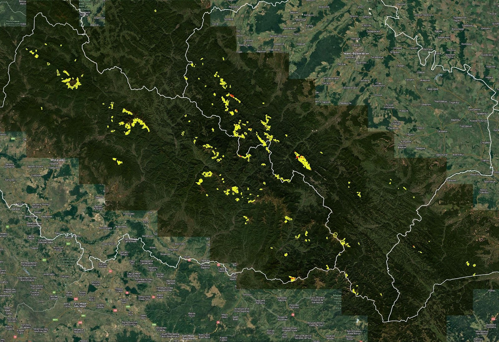
Figure 1. Planet Basemaps satellite composite for September 2025 covering high-value forest areas in the Carpathians. Verified areas are marked in yellow; areas covered by shadows are marked in red.
In autumn, the sun sits lower above the horizon compared to summer months. As a result, the angle of sunlight is reduced, creating longer shadows on mountain slopes.
Thus, in September, 1,408 areas with a total area of 17,467.1 ha were inspected, representing 98.18% of all areas defined for monitoring. No disturbances of forest cover were detected in the inspected areas.
October 2025
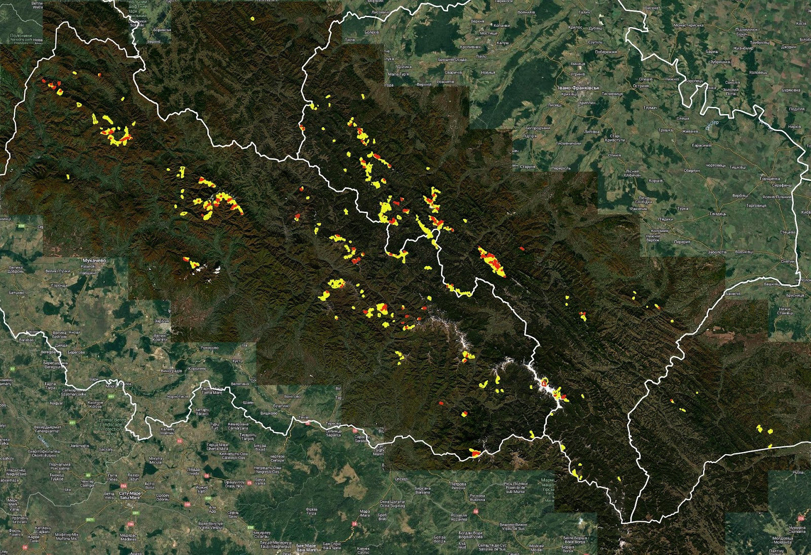
Figure 2. Planet Basemaps satellite composite for October 2025 covering high-value forest areas in the Carpathians. Verified areas are marked in yellow; areas covered by shadows, clouds, or snow are marked in red.
Due to mountain shadows, cloudiness, and occasional snow cover, in October 1,191 areas with a total area of 14,979.8 ha were inspected, representing 83% of all areas defined for monitoring. No disturbances of forest cover were detected in the inspected areas.
The publication is produced by NGO «ForestCom» with the support of the Askold and Dir Fund as a part of the Strong Civil Society of Ukraine – a Driver towards Reforms and Democracy project, implemented by ISAR Ednannia, funded by Norway and Sweden. The contents of this publication are the sole responsibility of NGO «ForestCom» and can in no way be taken to reflect the views of the Government of Norway, the Government of Sweden and ISAR Ednannia.
Previous satellite monitoring reports on primeval forests:
Satellite Monitoring of the Carpathian Old-Growth Forests: July 2025